GPS Assists Major Mine Cleanup
by Don Talend
Contractor relies on GNSS – an advanced global positioning system (GPS) – for efficient reclaiming of land and water impacted by abandoned coal mines in Pennsylvania
It may be that something is getting lost in the midst of recent highly publicized debate about the Earth's environmental future: Technology can preserve precious resources such as water – not just adversely affect those resources.
An example of technology as an environmental steward is recent use of a Global Navigation Satellite System (GNSS) in constructing acid mine drainage systems and reclaim abandoned coal mine sites near Benezette, a town in rural northwest Pennsylvania. Since a coal mining boom ended there years ago, elk viewing and hunting and all-terrain vehicle (ATV) sightseeing are what bring tourists to Benezette and boost its economy.

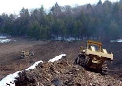
In early 2008, Jim Irey, a civil engineer and vice president of Berner Construction of Gap, PA, located about 4-1/2 hours to the southeast, completed his fifth coal mine reclamation project in the area in the past two years. Berner Construction began using a GNSS system from Topcon Positioning Systems for site preparation and construction machine control in 2007.
Dangerous Legacy
Like much of the state, the area has numerous abandoned coal mines with a great deal of sulfur residue. Sulfur reacts with air and pyrite to form sulfuric acid that contaminates water flowing through the mines. The acidic water, which cannot support aquatic life, finds its way to Chesapeake Bay to the east, where it adversely alters the bay's ecosystem – not to mention those of watersheds en route. Improving water quality in Chesapeake Bay is a priority of the U.S. Environmental Protection Agency and one that's united various entities in the respective states surrounding it under auspices of the Chesapeake Bay Program, a watershed management group that coordinates with multiple agencies and stakeholders. Certainly, Pennsylvania isn't the only state with coal-mining legacy problems, but its problems are generally considered more widespread than states such as West Virginia and Ohio.

The Pennsylvania Bureau of Abandoned Mine Reclamation estimates the state has about 250,000 acres of abandoned surface mines in 45 of its 67 counties with dangerous high walls – a safety hazard to ATV and snowmobile riders. A more widespread safety hazard is the roughly 24,000 miles of streams in the state that don't meet water quality standards due to drainage from abandoned mines. In late 2007, the U.S. Office of Surface Mining provided Pennsylvania with the first installment of $1.36 billion that the federal government is giving the state over 18 years to reclaim 184,000 acres of abandoned mines on 5,100 sites. The state calls acid mine drainage its biggest water pollution problem.
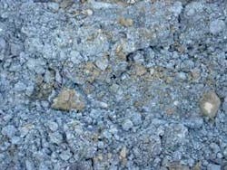
Passive treatment systems can correct this problem on a wide scale. A typical passive system consists of channels lined with high-calcium limestone to lower the acidity of the sulfuric acid-contaminated water flowing over it, as well as basins lined with compost and wood chips that impart bacterial activity to the water – lowering the pH and forming the biological building blocks that support aquatic life.
Earthmoving Experience
During one of Berner Construction's mine reclamation projects, a Topcon HiPer Light+ base receiver located on high ground receives satellite positioning signals. These signals are transmitted to a HiPer Light rover system and used to create a three-dimensional survey model of the site. The dozer operator views the 3-D model inside a monitor mounted in the cab and the base station transmits signals to the rover – which, during earthmoving, is mounted on front of a dozer used for finish grading – while the site is graded. The GNSS data, information drawn from Topcon's dual-constellation system, that uses both U.S. GPS and Russian GLONASS satellites for constant reception, indicates to the operator how near to specification the dozer blade is at any given moment, allowing precise, continuous grading adjustments.
On one abandoned mine site outside of Benezette, Berner Construction has multiple objectives: level out a ridge formed by deposits of soil previously overlying a coal seam, create a downward slope to facilitate acid mine drainage, line the slope with high-calcium limestone and eliminate 50-foot high walls.
Irey accesses the same 3-D model on his handheld Topcon FC-100 field monitor that the fine-grading dozer operator sees on his in-cab monitor. He can even see a black line on his field monitor indicating where a high calcium limestone-lined drainage swale will be dug to channel acidic runoff from the slope.
“This is the entire jobsite – it's about 8,000 feet from end to end,” Irey says, pointing to the crescent-shaped model on his field monitor. Then he turns to the charcoal-colored stockpiled limestone to be placed after grading is complete. “This material is a byproduct that we use,” he says. “It's waste material from a quarry that met the specification for high-calcium limestone material. The quarry had 400,000 yards of it and we got it approved through the state as a beneficial waste material. They sell it to us for a reduced price.”
Productivity Enhancers
The real benefit of GNSS in this situation is productivity. The company essentially does its own surveying and site preparation, keeping its machines moving dirt as much as possible.
Irey took note of how use of GNSS is changing surveying and site preparation methods. “There are fewer and fewer people who can do traditional survey work,” he says. “But it will always be required in certain situations. In today's world, you're now looking at computer screen similar to the screen that a kid looks at when he's playing an electronic game.”
Conditions of abandoned mine sites in this part of the state provide an advantage to productivity, Irey explains. In south central Pennsylvania, for example, miners were more likely to pile dirt from their excavations near the high walls, necessitating downhill grading. For downhill grading, a GNSS provides more of a benefit in terms of grading accuracy. “These jobs are all uphill pushes, so as long as we have pretty consistent grades throughout the site, we're OK. The issue with downhill grading is that it goes much faster, so if you overfill an area you overfill it fast, and it may take you three to four times as long to level it out.”
The use of GNSS minimizes the need for Berner Construction to use conventional methods of site preparation involving the use of grade stakes. “We would just put stakes up the hill and run a level on it, which is very hard to do to get control on the hill,” Irey notes. “What [the GNSS] does is allow me not to be here. We pride ourselves on the fact that once the site is set up, short of moving the base station around, it's good to go for the entire job.”
Acknowledgment: The author would like to thank Topcon Positioning Systems Inc., of Livermore, CA, for its assistance on this article. Contact: 925-245-8300 or www.topconpositioning.comAbout the Author: Don Talend of Write Results, of West Dundee, IL, is a communications and publicity consultant specializing in the trade media.