USGS releases new drought forecasting tool
Key Highlights
- The U.S. Geological Survey (USGS) released a new machine learning tool that forecasts droughts up to 90 days ahead nationwide.
- River DroughtCast currently provides forecasts for more than 3,000 USGS streamgage locations.
The U.S. Geological Survey (USGS) released a new machine learning tool that forecasts droughts up to 90 days ahead nationwide. The tool may provide communities extra time to prepare for water shortages that could impact agriculture, municipal supplies, recreation, and ecosystems.
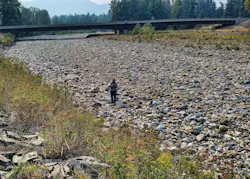
USGS River DroughtCast forecasts streamflow drought, which is when rivers and streams drop below normal levels for extended periods, which may directly impact water availability even when rainfall returns to normal. It uses machine learning models trained on data from thousands of USGS streamgages, some with more than 100 years of continuous records, to forecast when rivers and streams will drop to abnormally low levels.
A user of the tool can choose any length of forecast between 1-13 weeks, with the tool being most reliable in the first 4-6 weeks. Regardless of the length of the forecast, the first week of severe or extreme drought conditions are correctly predicted about 75% of the time. This reliability drops to about 55% of the time by week 13. All forecasts include confidence estimates so users can understand the reliability of predictions during different timeframes.
River DroughtCast currently provides forecasts for more than 3,000 USGS streamgage locations with at least 40 years of data. Developers are working on the next version to expand public access to areas without gauges and to further improve forecast accuracy.