University of Illinois develops city flood forecasting system
Key Highlights
- The Discovery Partners Institute (DPI) developed a city-scale flood forecasting system.
- The system’s GPUs process flood models across complex city landscapes and drainage networks at high speed.
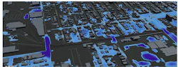
The Discovery Partners Institute (DPI) Climate Hub at the University of Illinois has developed a graphics processing unit (GPU)-driven city-scale flood forecasting system rather than across broader regions.
The GPUs process physics-based flood models across complex city landscapes and drainage networks at high speed. The forecasting system could reduce flood simulation time by up to 80%, enabling emergency managers to anticipate impacts as storms unfold rather than after the fact.
The study shifts flood forecasting from static risk maps to dynamic, real-time intelligence that enables faster and more informed decisions. It forecasts when, how quickly, and who will be impacted ahead of time.
Urban flooding is driven by extreme rainfall, rapid urbanization, and aging drainage systems. Today, nearly 1.8 billion people live in flood-prone areas globally, with economic losses reaching hundreds of billions annually.
In addition to improving public safety and reducing economic losses, enhanced flood modeling supports environmental protection by reducing contamination from floodwaters, limiting ecosystem damage, and informing more sustainable infrastructure and water management decisions.
The project was guided through collaboration with the City of Chicago, the Metropolitan Water Reclamation District of Greater Chicago (MWRD), and state agencies.