Water Agency Flows Freely With Land Development Desktop Software System
Turn on a faucet in Cincinnati, OH, and you'll get some of the cleanest drinking water in the nation, at a reasonable monthly rate. Those results are the product of hard work by the city's water utility, Cincinnati Water Works - and several years of investments in technology, expansion and quality control.

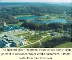
The city built a carbon filtration system that has been hailed by environmental advocates and regulators as the finest in the country, because it yields high-quality water while using much less chlorine than most purifiers. And because its plants can pump a massive 260 mgd, Cincinnati Water Works has been able to broaden its reach - running pipes out to Warren, Butler and Clermont counties, even tunneling under the Ohio River to Kentucky's Boone County. The new business has helped to keep water bills down for Water Works' 900,000 customers.
As part of a sweeping, $30 million software upgrade begun in 1993, the utility equipped its engineers with computer-aided design (CAD) stations. That move alone doubled the engineers' productivity, since before they had been designing on mylar sheets. Today that software includes Autodesk's AutoCAD 2000i, Land Development Desktop 2i, Civil Design, Survey and CAD Overlay.
Having better tools has helped - especially since the utility's expansion into nearby jurisdictions has meant a brisk pace for its surveyors, designers and inspectors. Cincinnati's distribution system includes about 2,800 miles of water main, and the utility plans to replace 1 percent of those pipes every year.
Agency Challenges
Challenges for the Water Works agency include maintaining accurate maps, collaborating with other jurisdictions as it expands into new regions and supporting a mobile workforce. In order to maintain accurate pipeline maps, Water Works has a constant need to check its records against what's actually in the ground - especially when crews have worked in the area or when they run across places that simply aren't in the system.
"For example, we have a number of townships that served as their own small governments within the city, with their own design standards," said William Martin, a programmer analyst in Water Works' engineering division. "Some of those maps are a hundred years old, archived on vellum sheets. To bring those records into our database, we send surveyors out to make the measurements."
When surveyors go to a job site, they bring map data from a citywide consortium, the Cincinnati Area Geographic Information System (CAGIS), which maintains a shared repository of GIS maps. Those records are in a different mapping format, ESRI's ArcView Shape files. The surveyors then measure distances as "points" - the position of a gas line that must be crossed, for example, or a manhole cover - and bring those figures back to the agency's designers, who adjust their maps or make new ones. This posed a challenge for Water Works: it either had to adopt an ESRI design system or find another that was flexible enough to handle ESRI and other file types.
Another priority was collaboration. As Water Works has expanded into other counties - even other states - its engineers increasingly work with counterparts in neighboring jurisdictions. And for large downtown projects, the agency often works with private consultants. For those reasons, the utility sought software that would enable its staff to share map data with contractors.
Finally, the utility needed a product mobile enough to allow access to maps on handheld devices, so that when its inspectors respond to a water main break or other trouble spot, they could make quick measurements without lugging paper maps around.
Solution/Benefits
To meet its main challenges and for many other reasons, the utility chose to standardize its designers and planners on Autodesk.
"It wasn't a hard decision," Martin said. "Even though the consortium's GIS maps are in ESRI format, Autodesk easily converts files from that format and others, and the software is so straightforward that our designers mastered it quickly."
The software was also well suited to the agency's Windows NT servers.
"We are a Windows office," Martin said. "The Autodesk interface is very graphic, very Windows-friendly, with menus that are easy to configure. Adopting a program like Microstation probably would have required buying a Unix server; it just wasn't an option."
When surveyors return, their "point data" is imported into a Land Development Desktop (LDD).
"The designers use Survey to manipulate the survey data, and we're starting to use LDD's terrain models more to map the contours of the landscape," Martin said. "Then they use Civil Design to layer it all together with GIS maps into cross-sections. You end up with a final diagram that very accurately reflects what's out there - gas, electric, telecommunication lines and topography."
Martin says his designers used to spend considerable time double-checking survey data, but no longer.
"The surveyors themselves composed field drawings, and if they didn't make sense to the designer, he or she had to go out again and make their own measurements. But with LDD, the numbers come straight out of the surveyors' EDM (Electronic Distance Measuring) device, or a GPS station. LDD allows you to interpolate the survey data better - to be a more accurate designer."
The Internet-enabled features of AutoCAD 2000i helped Martin set up a Web site for a team of engineers and consultants who are drilling under the Ohio River. For this large project, in which Water Works will supply water to the city of Florence and Boone County, KY, Martin designed a site with maps, news articles, cost analyses and a private chat room. Martin also is considering starting a Web-based intranet for the agency that would allow quick access to maps.
"For that and some other things, we're looking at MapGuide," an Autodesk product that delivers map and design data through a Web-based interface.
Water Works also can extend its maps beyond the desktop to handheld devices with Autodesk's Volo View, which allows users to view and mark up map files without AutoCAD software.
"If an inspector goes out to a pipe installation, he or she can get a quick vector or raster image of the drawing on his handheld with Volo View," Martin said. And he expects the inspectors soon will start using the next generation of Autodesk's mobile tools, Autodesk OnSite, to mark up the map on a layer, bring it back to the office, and sync up the handheld with a designer or a planner.
"And at some point I'd like for us to have a real-time connection between the inspector in the field and our office - so he can transfer that data from his handheld to us, instantly, via a Web server," Martin said. "The technology is there."